
Halifax Multi-Model Forecast Engine
Our newest forecast product is built on a custom multi-model weighted blending engine that ingests output from nine independent numerical weather prediction models and two ensemble systems across twelve geographically distributed stations, fuses them through time-dependent weighted averaging, applies ensemble-derived bias correction, and renders the result into zone-aware, region-specific forecast products for the Halifax area.
Models
The engine queries nine distinct NWP systems, each selected for a specific forecast horizon and geographic strength:
Short-Range (0–18 hours):
- GEM HRDPS Continental (CMC, 2.5 km) — Environment Canada’s high-resolution deterministic model, updated every 6 hours, helping provide the short-range baseline.
- HRRR CONUS (NOAA/NCEP, 3 km) — NOAA’s High-Resolution Rapid Refresh model, updated hourly, contributes rapid-update convective and boundary-layer detail.
Mid-Range (18–240 hours / Days 1–10):
- GEM Seamless (CMC, variable resolution) — Environment Canada’s blended global-to-regional deterministic chain, updated every 12 hours, one of three mid-range signals.
- NBM CONUS (NOAA/NCEP, National Blend of Models) — A statistically post-processed multi-model blend updated hourly, contributing calibrated probabilistic guidance.
- ECMWF IFS (European Centre, ~9 km) — High-performance global deterministic model, updated every 6 hours.
Long-Range (240–384 hours / Days 10–16):
- ECMWF IFS (European Centre, ~9 km) — Continuity from mid-range to help anchor the extended outlook.
- GFS Seamless (NOAA/NCEP) — NOAA’s global model chain, providing a second independent long-range perspective.
- AI GFS 0.25° (NCEP machine-learning post-processing) — A neural-network-derived correction layer applied to GFS output, contributing a data-driven third opinion.
Ensemble Systems:
- HGEFS 0.25 Ensemble Mean (NCEP, 10-day) — A 31-member global ensemble used for short-to-mid-term bias correction of the deterministic blend.
- General Ensemble (Open-Meteo multi-model, 30-day) — A broad ensemble spread used for confidence quantification, model divergence language, and long-term trend detection beyond day 14.
Blending Methodology
Time-Dependent Weighted Averaging
Rather than selecting a single “best” model, the engine computes a weighted average across all available models at every forecast hour, with weights governed by a smoothstep transition function:
| Forecast Hour | Primary Models | Weights |
|---|---|---|
| 0–18 h | GEM HRDPS + HRRR | 50% / 50% |
| 18–240 h | GEM Seamless + NBM + ECMWF IFS | 35% / 35% / 30% |
| 240–384 h | GFS + ECMWF IFS + AI GFS | 35% / 35% / 30% |
Transitions between regimes are not abrupt. A ±4-hour smoothstep ramp ensures that, for example, at hour 17 the blend is still 87% short-range and 13% mid-range, preventing discontinuities in the forecast timeline.
Ensemble Bias Correction
After the deterministic blend is assembled, the engine computes the bias between the blended output and the HGEFS/General Ensemble means over their overlapping time window. Thirty percent of this bias is applied as a nudge to the blended forecast—enough to correct systematic model drift without over-fitting to a single ensemble realization. The same nudge is applied to the model spread envelope (min/max across contributing models) to prevent visual detachment between the forecast line and its uncertainty band on charts.
Model Spread Tracking
At every forecast hour, the engine records the minimum and maximum values across all contributing models for each variable. This produces a continuous uncertainty envelope rendered at 25% opacity on the 120-hour and outlook charts, giving readers a visual sense of model agreement or divergence.
Variable-Specific Blending
- Continuous variables (temperature, wind speed, humidity, pressure, precipitation): weighted arithmetic mean.
- Wind direction: weighted circular mean (vector averaging).
- Weather codes: weighted vote — the WMO code receiving the highest cumulative weight across models is selected.
Spatial Architecture
Station Network
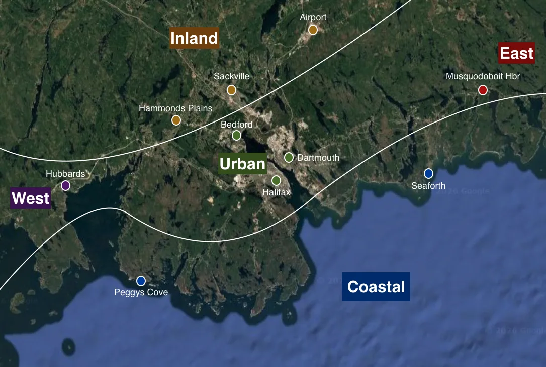
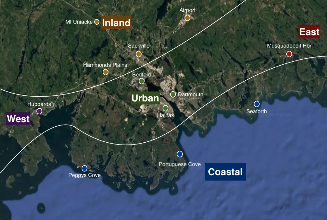
The engine queries all nine models at each of twelve fixed coordinate nodes distributed across the HRM:
| Zone | Stations | Role |
|---|---|---|
| Urban | Halifax, Bedford, Dartmouth | Urban core |
| Inland | Mt Uniacke, Sackville, Halifax Stanfield Airport, Hammonds Plains | Inland influence signal |
| Coastal | Peggy’s Cove, Portuguese Cove, Seaforth | Coastal influence signal |
| Eastern | Musquodoboit Harbour | Eastern (Eastern Shore, coastal transition) signal |
| Western | Hubbards | Western (St Margarets Bay/South Shore, coastal transition) signal |
Zone-Weighted Aggregation
Individual station blends are aggregated into zone means (equal weight within a zone), then combined into a single HRM-wide forecast using fixed zone weights:
- Urban + Inland = 60% (the “bullseye” — where population density is highest)
- Coastal + Eastern + Western = 40% (modifier zones that capture marine, topographic effects and transitions)
This weighting helps ensure the headline forecast reflects the metro core while preserving the ability to detect and communicate meaningful zone-to-zone differences.
Dynamic Regional Modifiers
For every forecast time block (4-hour periods in the short term, full days in the outlook), the engine independently evaluates zone divergences and appends the single most significant modifier to the forecast cell:
- Temperature: Coastal vs. urban or inland vs. urban deltas at ±2.5°C (“cooler along the coast”) and ±5°C (“much colder inland”) thresholds.
- Frost risk: Flagged when inland minimums drop to ≤2°C while urban or costal minimums remain above 4°C.
- Cloud cover: ±25% mean difference between zones (“clearer inland”, “cloudier along the coast”).
- Wind: Coastal gusts exceeding urban by 15 km/h (“breezy along the coast”) or 25 km/h (“much windier along the coast”).
- Precipitation: Inland vs. coastal or east vs. west sums differing by >2 mm (“heavier rain inland”, “showers favoured east of Metro”).
When multiple modifiers qualify, the engine selects from the highest-weighted tier.
Ensemble Fetch Optimization
Ensemble data is fetched at four maximally separated stations from the core (Halifax, Airport, Musquodoboit Harbour, Hubbards) and propagated to all other stations.
Processing Pipeline
- Model-Aware Caching: Each model’s output is cached to disk with a TTL matched to its update cycle (1 h for HRRR/NBM, 6 h for GEM HRDPS/ECMWF/GFS, 12 h for GEM Seamless).
- Resampling & Alignment: Models with 3-hour or 6-hour native resolution are upsampled to hourly via linear interpolation (numeric variables) and forward-fill (categorical variables). All models are aligned to a unified hourly time index before blending.
- Blending & Correction: Time-dependent weighted averaging → ensemble bias nudge → daily aggregation (max/min/mean/sum/mode as appropriate per variable).
- Narrative Generation: The blended hourly and daily DataFrames feed into a natural-language narrative engine producing a detailed 48-hour prose forecast, a 14-day outlook with model divergence quantification, and a long-term ensemble trend statement (days 15–30 vs. days 1–14).
Products
Short-Range (0–48 h): Six 4-hourly forecast cells for today and tomorrow, each displaying a weather icon, condition text, temperature, wind speed/gust/direction, precipitation probability, dewpoint and feels like, UV index, thunderstorm risk, visibility and fog along with a dynamic regional modifier. This is accompanied by a detailed prose narrative and a 120-hour temperature/precipitation chart with model spread shading.
Almanac Panel: Climate-normal high/low with departure, record high/low/precipitation for the date, sunrise/sunset/daylight duration, and current moon phase.
Extended Outlook (Days 3–15): Daily forecast cells with high/low temperatures, icons, wind, precipitation probability, and regional modifiers. A 15-day outlook chart with high/low spread envelopes. Prose narrative includes quantified model divergence (“Model spread on Thu Jul 30 rainfall: 2.1 to 8.4 mm”) and long-term ensemble trend language.
Model Uncertainty Communication: The 25%-opacity spread envelope on charts, explicit divergence text in the narrative, and ensemble-derived confidence metrics provide readers with an honest representation of forecast certainty that degrades gracefully with lead time.